07 Jan Virtually Explore America’s Quietest Roads

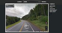
America’s Quietest Roads is an interactive map created by a road traffic analytics company called Geotab. The map features the quietest state or federal highway in all fifty states. They define…
Read the whole entry at FreeTech4Teachers.com »
Related Stories
- Seven Apps and Sites to Encourage Healthy Diet and Exercise Habits
- Vintage Travel Posters and Google Earth
- City Walks – Hear and See Cities Around the World
America’s Quietest Roads is an interactive map created by a road traffic analytics company called Geotab. The map features the quietest state or federal highway in all fifty states. They define…Read the whole entry at FreeTech4Teachers.com » Related StoriesSeven Apps and Sites to Encourage Healthy Diet and Exercise HabitsVintage Travel Posters and Google EarthCity Walks – Hear and See Cities Around the World  digital maps, Free Technology For Teachers, Geography, History, Interactive Maps, Maps, Social StudiesRead More
Sorry, the comment form is closed at this time.