17 Mar An Interactive Map of Surnames in Ireland
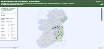
Mapping the Emerald Isle: a geo-genealogy of Irish surnames is an interactive map depicting the distribution of Irish surnames across Ireland according to the 1890 census. To use the same simply select a name from a drop-down menu in the list and the map will change to show you in which counties people with that surname lived in 1890. The map will also provide you with a list of number of households with that surname in each county. For example, I discovered that there were 301 Byrne households in Dublin county in 1890.
Applications for Education
This is a neat example of mapping data. Your students could create similar maps using either ESRI’s mapping tools or Google’s My Maps tools. I have found Google’s My Maps tools to be easier for new users to understand. A playlist of tutorials about Google’s My Maps can be seen here.
Mapping the Emerald Isle: a geo-genealogy of Irish surnames is an interactive map depicting the distribution of Irish surnames across Ireland according to the 1890 census. To use the same simply select a name from a drop-down menu in the list and the map will change to show you in which counties people with that surname lived in 1890. The map will also provide you with a list of number of households with that surname in each county. For example, I discovered that there were 301 Byrne households in Dublin county in 1890.Applications for EducationThis is a neat example of mapping data. Your students could create similar maps using either ESRI’s mapping tools or Google’s My Maps tools. I have found Google’s My Maps tools to be easier for new users to understand. A playlist of tutorials about Google’s My Maps can be seen here.Are you a tech coach or media specialist looking for some new ideas to share with your colleagues? If so, 50 Tech Tuesday Tips is an eBook you need. You can get it right here. ESRI, Free Technology For Teachers, History, Interactive Maps, Social Studies, St. Patrick’s DayRead More


Sorry, the comment form is closed at this time.