08 Apr A Video Tour of 17th Century London in 3D
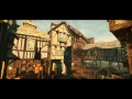
This morning I read a BBC article about the rediscovery of the oldest 3D map in Europe. The map is a roughly 5 x 6.5 foot slab of carved rock. Reading that article prompted me to start looking in my archives for collections of historical maps. While doing that I came across a video that I shared back in 2013. That video is an animated 3D tour of 17th Century London.
Pudding Lane Productions created a three and one half minute video tour to show viewers what London may have looked like prior to the Great Fire. The tour is based upon historical drawings and maps that the Pudding Lane Productions team researched. The video is embedded below.
Applications for Education
This video could be a good supplement to lessons about British history to show students a slightly different perspective of an overview of London that they may have read about or seen drawings of in textbooks.
This video might also inspire some ambitious students to create their own historical video tours of other cities they’re studying in history and geography classes. It’s possible to do that with the tour creation tool that is built into Google Earth Pro.
On a related note, in A Crash Course on Google Earth & Maps for Social Studies I teach how to make tours in Google Earth and how to overlay historical maps onto current Google Earth imagery.
This morning I read a BBC article about the rediscovery of the oldest 3D map in Europe. The map is a roughly 5 x 6.5 foot slab of carved rock. Reading that article prompted me to start looking in my archives for collections of historical maps. While doing that I came across a video that I shared back in 2013. That video is an animated 3D tour of 17th Century London. Pudding Lane Productions created a three and one half minute video tour to show viewers what London may have looked like prior to the Great Fire. The tour is based upon historical drawings and maps that the Pudding Lane Productions team researched. The video is embedded below.Applications for Education This video could be a good supplement to lessons about British history to show students a slightly different perspective of an overview of London that they may have read about or seen drawings of in textbooks. This video might also inspire some ambitious students to create their own historical video tours of other cities they’re studying in history and geography classes. It’s possible to do that with the tour creation tool that is built into Google Earth Pro. On a related note, in A Crash Course on Google Earth & Maps for Social Studies I teach how to make tours in Google Earth and how to overlay historical maps onto current Google Earth imagery. This post originally appeared on FreeTech4Teachers.com. If you see it elsewhere, it has been used without permission. Sites that regularly steal my (Richard Byrne’s) work include CloudComputin , 711Web, and Today Headline. 3D Maps, Educational Videos, Free Technology For Teachers, Geography, Google Earth, google maps, History, History Videos, London, Social StudiesRead More
Sorry, the comment form is closed at this time.