24 Dec 4,000+ Maps of Military Battles and Campaigns
The Library of Congress housed hundreds of thousands of maps covering a huge array of topics from maps used by fire insurance companies to population density to maps of military battles and campaigns.
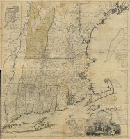
The LOC’s collection of maps of military battles and campaigns contains more than 4,000 maps that are free to view, download, and reuse. The vast majority of the maps are from the 18th and 19th centuries although there are about 600 maps covering World War I and II.
You can browse through the collection according to date, location, subject, and language (most of the maps are in English or French). Once you’ve found a map that seems interesting, click on it to view more information about the cartographer and a little backstory on the map. Most of the maps can be downloaded as images and some can be downloaded as PDFs.
Applications for Education
My first thought when looking through the collection was to download the maps to use as overlays in Google Earth. Doing so can provide students with some geographic context and comparisons for military battles and campaigns that they’re learning about in U.S. History classes. Directions for overlaying historic maps onto Google Earth can be found in this video.
The Library of Congress housed hundreds of thousands of maps covering a huge array of topics from maps used by fire insurance companies to population density to maps of military battles and campaigns. The LOC’s collection of maps of military battles and campaigns contains more than 4,000 maps that are free to view, download, and reuse. The vast majority of the maps are from the 18th and 19th centuries although there are about 600 maps covering World War I and II. You can browse through the collection according to date, location, subject, and language (most of the maps are in English or French). Once you’ve found a map that seems interesting, click on it to view more information about the cartographer and a little backstory on the map. Most of the maps can be downloaded as images and some can be downloaded as PDFs. Applications for EducationMy first thought when looking through the collection was to download the maps to use as overlays in Google Earth. Doing so can provide students with some geographic context and comparisons for military battles and campaigns that they’re learning about in U.S. History classes. Directions for overlaying historic maps onto Google Earth can be found in this video. If you’re interested in learning more about using Google Earth and Google Maps in your classroom, enroll in my self-paced Crash Course in Google Eath & Maps for Social Studies.
Sorry, the comment form is closed at this time.